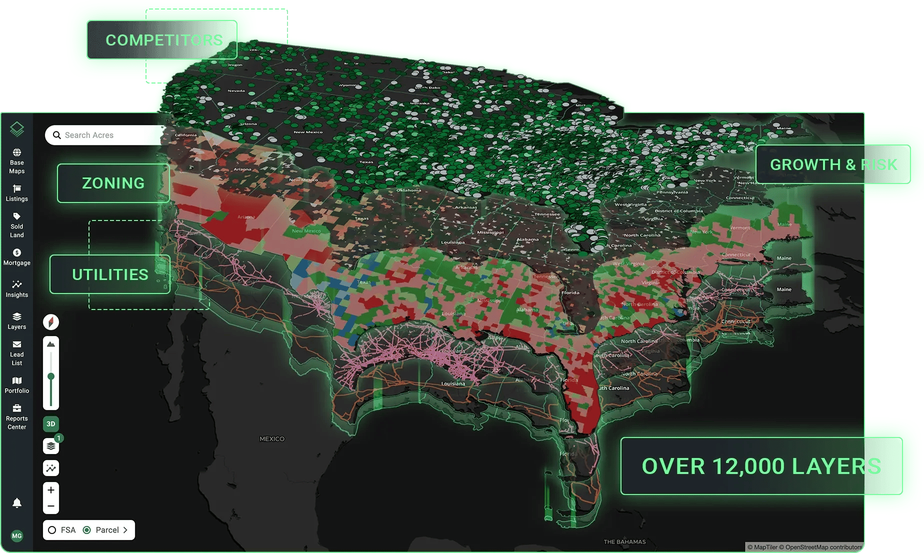
Maps & Data for Land People

Understand and value land with confidence.

A preview of Acres for desktop and mobile

TRUSTED BY LAND PROFESSIONALS

  • Peoples Company
  • Pearson Realty
  • Conterra
  • Halderman
  • AgHeritage
  • LandReport
  • Farm Credit
  • Schuil
  • Ag Economic Insights
  • Forsik
  • REACH
  • Equitable AgriFinance
  • Land Leader
  • Murray Ag Real Estate

Access Relevant Land Sales Data

Search the latest and most relevant land sales data, with nationwide coverage (even in non-disclosure states).

An example market analysis report
An example custom map

Easy Mapping and Land Data

Research land with easy to use map layers, and create shareable custom maps for any property in the U.S.

Find U.S. Landowners

Find landowner information for over 150 million U.S. parcels, whether you’re prospecting for leads or looking up your neighbors.

View parcel details like ownership data
Property report example

Shareable Reports in Minutes

Need to send a property report or comparative market analysis to a client? With Acres, you can quickly export maps and data to PDFs for easy sharing.

WHAT PEOPLE ARE SAYING

  • “I have been amazed how many changes they are making, many of which are helpful for our California and permanent crop environment. I find myself using the sold land, property search, and customizable report features the most. I use them for my analysis and as part of my marketing summary for clients."

  • "I always looked each parcel up individually online. Very time consuming! Thank you for a great app that have me back hours of my time!"

  • "I have been using the Acres product as a regular part of my business for almost a year now, and I wanted to let you know how great I think the Acres tool is.  [...]  Any agent working in the land industry should be using this tool."

  • "They’ve got a wealth of information, including parcel boundaries, owner names, great imagery, soil scores, topo map. I like that I can easily find a property and share it or save it for later."

  • "What an amazing app. It's absolutely full of information for your investment business or personal interest. An app that's resourceful for several reasons, but I'd rate it 10 stars if I could."

  • "This app is a groundbreaker that's been needed for a long time, just a colossal data-gathering undertaking. Nice work."

  • "Acres has saved me a lot of time and effort, as I no longer need to juggle between multiple mapping platforms. I highly recommend Acres to anyone in the real estate industry."

  • "Acres is a great tool that I utilize constantly. It provides easy access to data that I normally can't easily find. I use Acres to quickly access property features like flood zones and the topography."

How the Pros are Using Acres

Land Valuation

Whether you're valuing a property or setting a listing price, Acres makes it easy to find recent and relevant comparable sales. 

→ Filter sales by crop type, soil scores, water districts, and more.

→ Find land sales nationwide, including in non-disclosure and partial disclosure states.

→ Build PDF reports or editable CSV spreadsheets.

Request Demo

Marketing

Prospect for new opportunities and create marketing collateral that impresses potential clients.

→ Identify leads using advanced search filters and export lists for direct mail campaigns.

→ Customize PDF property reports featuring your brand and GIS insights.

→ Win more deals with the ability to deliver reliable data in minutes, not days.

Request Demo

Custom Mapping

Build custom maps across both desktop and the mobile app so you can showcase a property and make an impact.

→ Customize a map with boundaries, points of interest, notes, and photos.

→ Embed fast-loading custom maps directly in listings and on websites.

→ Send direct links to any property or custom map.

Request Demo

Land Research

Research millions of parcels across the U.S. with nationwide access and interactive data layers.

→ Analyze a property with easy to use GIS insights, like elevation, historic imagery, soils, and more.

→ Lookup landowner information and map entire portfolios with advanced search filters.

→ Search a national mortgage database to keep tabs on the market and your competition.

Request Demo

Land Management

Manage properties and plan projects with a suite of easy to use tools that save you time.

→ Quickly analyze important insights, like soil quality, elevation, and past land use with interactive GIS layers.

→ Manage multiple properties and share important maps and documents across a team with a secure portfolio view.

→ Plan projects with shareable custom maps that can be accessed while you're in the field.

Request Demo

Get the Latest from Acres

Mid-South Farmland Values

The latest farmland values report from Acres' data science team digs into farmland values in the Mid-South region over the past five years.