

Sewer access is one of the biggest factors in how quickly and affordably land can be developed. A parcel near existing sewer lines might support a full neighborhood of homes and move forward with fewer infrastructure hurdles. When sewer is nearby but not on site, extending a line or adding a pump station can add significant time and cost to a project.
With Acres.com, the national Sewer Lines layer shows sewer infrastructure across the country in one map, so you can see where service already runs before you make an offer.
Why Can Public Sewer Access Be Hard to Verify?
Builders know sewer access matters, but finding out where the lines actually are can be difficult.
- Every utility keeps its own maps: Sewer data is owned by local cities, counties, and utility districts. Each one stores it differently, and some only share it by request.
- Answers take time: Calling the utility, requesting maps, or waiting on an engineer's report can add weeks before you know if a site is worth pursuing.
- Distance changes the math: Even when sewer is nearby, the cost of running a line to your property can make or break a deal. Without a map, it's hard to estimate how far you'd need to go.
The result is time and money spent on land that may never work for homes.
Map of U.S. Sewer Lines
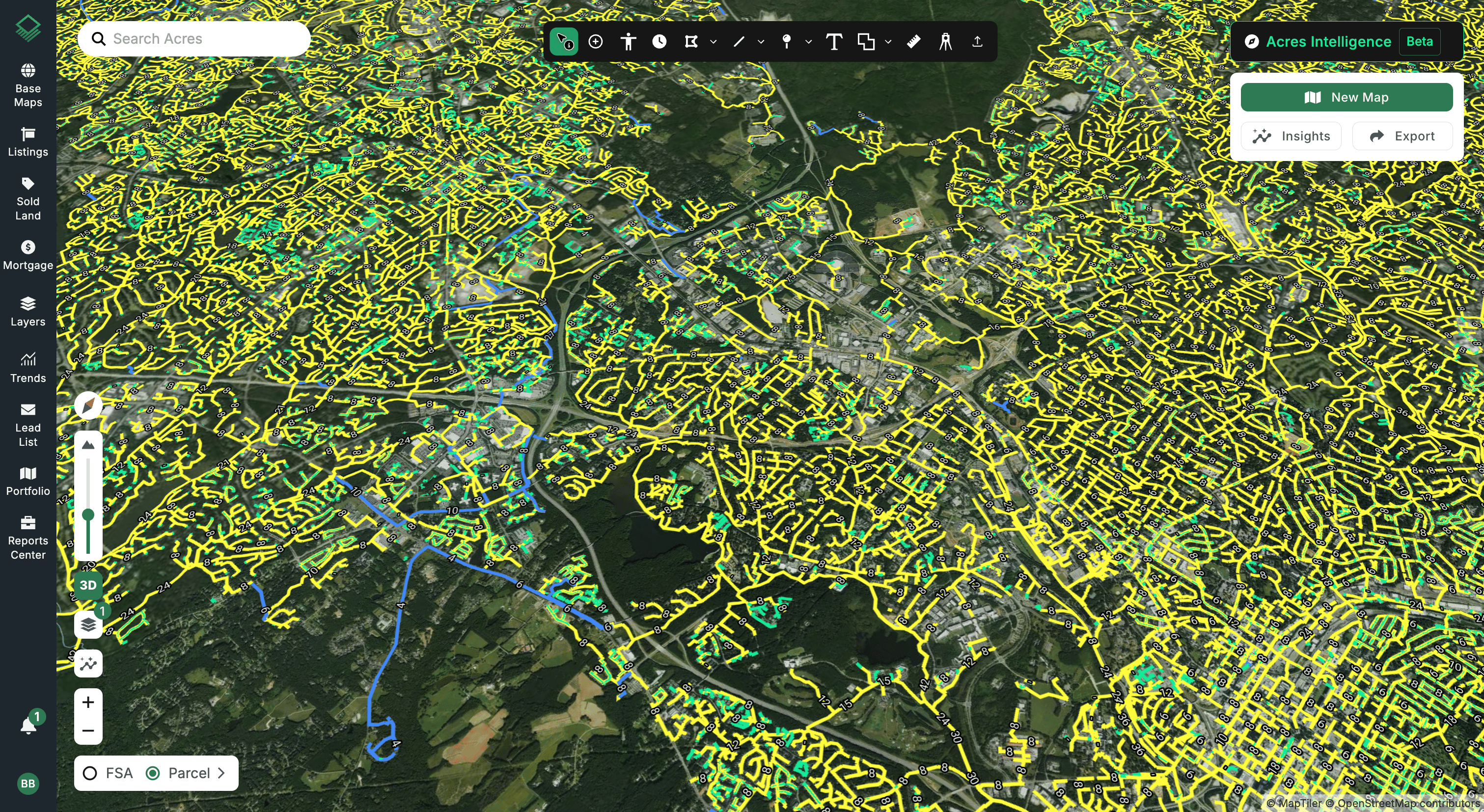
Acres' interactive Sewer Lines Map, available in our Layer Library, brings together sewer mains, force mains, and laterals compiled from local municipal utility data across the United States.
You can see sewer coverage in metro areas and growing communities nationwide with the lines right on the map, so you can visualize exactly where service runs along streets and through neighborhoods.
Connect with our sales team today to explore this and thousands of other data layers!
Note: Sewer lines in Acres are compiled from the map and GIS files local municipalities publish. Coverage reflects what those municipalities make available, and it continues to grow as more share their data.
You can sort and filter the layer by:
- Line type: Mains, laterals, force mains, trunk mains, and more
- Material: What the pipe is made of
- Source area: The local utility or municipality the data comes from
- Diameter: Pipe size, a quick indicator of how much flow a line is built to carry
Types of Sewer Lines on a Utility Map
Each line on the map is color coded by type. Here's what each type of sewer line means for developers:
- Main: The neighborhood sewer lines that typically run under streets and collect wastewater from homes and businesses. These are usually what a new subdivision would tie into.
- Lateral: The smaller pipes that connect individual buildings to the main.
- Force main: Pressurized lines that pump wastewater from a pump station, often uphill or over long distances.
- Trunk main: Large lines that carry wastewater from many mains toward a treatment plant.
- Unspecified/Other: Lines where the local data doesn't name a type.
How to Read a Sewer Line Map: Dover, Delaware Case Study
Here’s a look at how the layer works in a real market, using the area around Dover, Delaware as an example.
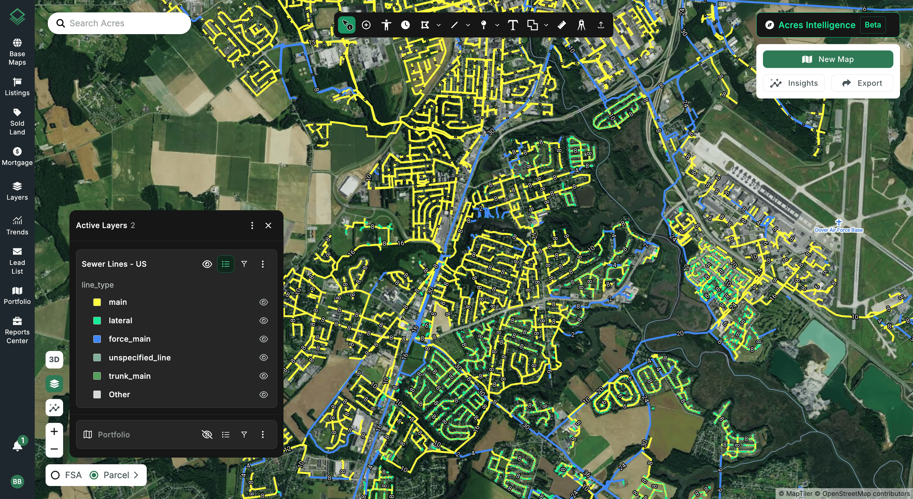
Dense networks of yellow mains run through the established neighborhoods, while larger blue lines follow the major roads and connect the system together.
Just as clear is where the lines stop. Beyond the edges of the network, there’s undeveloped land just outside of existing service. For a builder, those edges can be where opportunity lives.
Land just outside existing lines can often tie in with a short extension, while land farther out may need a longer, more expensive one. In a few seconds, you can see which parcels sit close to service and which would take more work to connect.
How Homebuilders and Developers Use Sewer Map Data for Site Selection
- Screen sites early: See whether a parcel is near sewer before you spend money on surveys, engineering, or a letter of intent. Builders and developers can rule sites in or out in minutes.
- Spot growth edges: Land just past the end of existing lines can signal where the next wave of subdivisions can go. The map makes those edges easy to find.
- Sewer vs. septic: Septic systems typically require larger lots, while sewer access can allow more homes on the same acreage. Knowing which you're working with shapes how many lots a project can support.
- Higher-density projects: Townhomes and multifamily communities almost always need public sewer, so access is a first filter for these sites.
Tip: With Acres’ Site Planner, you can draw your roads, set your lot sizes, and watch your lot yield update in real time, including total lot count, density, and net buildable acreage, all on the same map where you review sewer lines. It’s a quick way to test how many lots a site can support with and without sewer access before bringing in an engineer.
- Gauge extension costs: Measure how far a property sits from the nearest main to get an early sense of what it might cost to connect.
- Know before you offer: Sewer access affects what land is worth to a builder. Seeing it on the map helps you price offers and avoid paying for potential a site can't deliver.
Tip: Pair sewer access with Acres’ sold land data to see what comparable properties nearby have sold for. Comparing sold prices for sewer-served land with land that isn’t connected to sewer might help you set a realistic offer and back up your price in negotiations.
Evaluate Sewer Access and Buildable Land Faster with Acres
Sewer access can decide whether a piece of land becomes a neighborhood or stays undeveloped. The Acres Sewer Lines layer puts that answer directly on the map, with mains, force mains, and laterals from local utilities across the country in one place.
To get the most out of it, pair sewer lines with zoning, water lines, utilities, and environmental risk data to build a complete picture of any site. You'll know where service runs, what the land allows, and where to focus your next acquisition, all before your first call with a seller or engineer.
Explore this and thousands of other data layers in the Acres Layer Library to find buildable land faster and make confident site selection decisions.